Cartographic Materials Cataloging Manual
This manual outlines the local decisions of the Beinecke Manuscript Unit for applying the standard Descriptive Cataloging of Rare Materials (Cartographic) [1] to the cataloging of manuscript cartographic materials, coded as record type f in Yale’s catalog. It includes instructions and resources for data fields unique to cartographic materials, in addition to specific guidance for commonly-used fields. Only fields and subfields requiring guidelines specific to cartographic materials are in this manual. Therefore, catalogers must also consult the Yale University Library’s Manuscript Cataloging Guidelines and the Beinecke Manuscript Unit’s Manuscript Cataloging Manual for general guidelines. This manual was created by Ève Bourbeau-Allard in 2019 and is maintained by the unit’s cataloging coordinators.
The following guidelines focus on maps and atlases; consult DCRM(C) for instructions on cataloging three-dimensional globes. Because the drafting of DCRM(C) began during the transition from AACR2 to RDA, DCRM(C) retains AACR2 references. This manual reflects the Manuscript Unit’s decision to create RDA-compliant records. RDA informs the construction of access points, the spelling out of previously abbreviated terms, the choice of relationship designator terms, etc. This manual departs from DCRM(C) rules by requiring that date and place of production be recorded in a standard form, instead of transcribing as they appear on the material.
Backstage and OCLC export for record type f follow the same process as for record type p (mixed materials). Add your finalized record to YUL’s daily batch export to Backstage Library Works (OCLC’s authority control service) by checking the “OK to export” box on the System tab, and then clicking “Save to DB”. Your record will be automatically queued for YUL’s next weekly batch export to OCLC during processing by Backstage. After an initial export to Backstage/OCLC, any change saved to a record – in any field – will trigger the re-export directly to OCLC in the next weekly batch. If you make modifications to 1xx, 6xx, and 7xx fields, you should manually re-check the “Ok to export” box, so that Backstage edits URIs as necessary before re-export to OCLC.
Voyager templates for cartographic materials are located in the J Drive > Voyager templates > Cataloging > dcrmc. To use, copy and paste the dcrmc folder to your C Drive in C > Voyager > Catalog > Template. Go to Voyager > Options > Preferences > Folders/Files and select a file path for the bib template located in your C drive.
Bibliographic Records for Cartographic Materials
Requirements
The following fields are required in all records per national standards and local practice:
- Leader
- 007
- 008
- 034
- 040
- 043
- 052
- 245
- 255
- 264
- 300
- 336
- 337
- 338
- 506
- 520
- 561
- 524
- 651
- 655
- 852
Variable Control Fields
Leader
- Type of record: Use f – manuscript cartographic material. OPAC display: Label Format.
- Bibliographic level: Use m – monograph/item for single maps and atlases, or c - collections for multiple maps.
- Type of control: Use _ blank, no specific type of control.
- Cataloging form: Use i –ISBD included.
006
Do not use.
007 (Physical Description)
Generally, apply map (unless cataloging a globe). OPAC indexing: Search limit Medium.
- Specific material designation: Use j – for map, d – for atlas, etc.
- Color: Use a – for one color or c – for multicolored if the added color was part of the original production (this excludes later manuscript annotations in colored ink)
- Physical medium: Select as appropriate. Tracing cloth is g - textile.
- Type of reproduction: Select as appropriate. Generally, n – not applicable.
- Production/reproduction detail: Select as appropriate. Generally, z – Other.
- Positive/negative aspect: Select as appropriate. Generally, n – not applicable.
008
- Date 1 and/or 2: Must match 264 ‡c.
- Place of publication/production: Must match 264 ‡a.
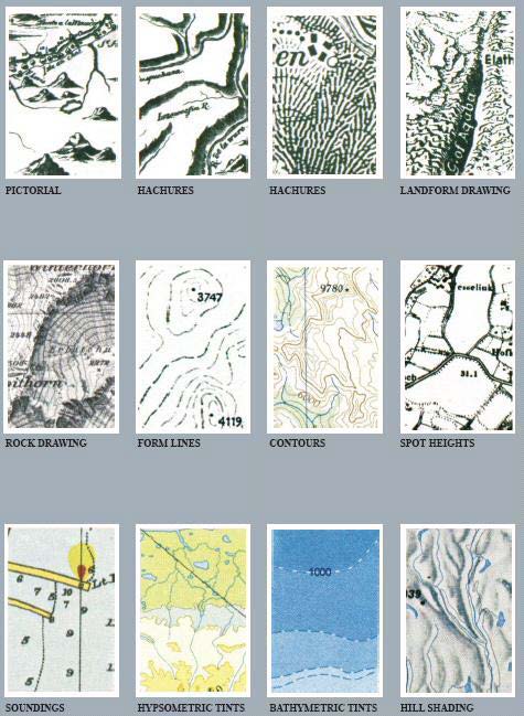
- Relief: Indicate each method of representing relief present on map, if applicable. Also record in a 500 note.
- Projection: Select as appropriate if specified on map. Must match 255 ‡b.
- Material: Select as appropriate, generally a – single map or e – atlas.
- Index: 0 if none, 1 if present.
- Special Format Characteristics 1: Use e – manuscript. Fill Special Format Characteristics 2 if applicable.
- Language: Must match 546. For two or more languages, also use 041 (Language Codes). For no linguistic content, use code zxx.
- Publication status: s - Single known date/probable date or i - Inclusive dates of collection for collections spanning multiple years or a single item encompassing a range of dates (for example, an atlas created over multiple years)
0XX
034: Coded Cartographic Mathematical Data
The 034 field (machine-readable format) captures the same information as the 255 field (human readable format). The 034 has no OPAC indexing or display, while the 255 displays in the OPAC. See 255. Metadata in the 034 must match the 255 field.
Repeatable field: If 2 scales are present on the material, use two 034 and two 255 fields. If there are 3 scales or more, do not repeat 034 and 255 fields. Instead, code the 034 first indicator 3 and use the 255 ‡a Scales differ.
First indicator (type of scale): 1 - Single scale, 3- Range of scales, or 0 - Scale indeterminable/No scale recorded
Second indicator (type of ring for digital cartographic items): generally blank - Not applicable.
‡a - Category of scale: required
- Use a – for all linear maps (even when no scale given, or scales vary within an atlas)
- or b – for celestial
- or z – for other.
‡b - Constant ratio linear horizontal scale: subfield required when scale is present on map, or when approximated by the cataloger.
- Refers to the denominator of the representative fraction (the numerator is always 1). It expresses how many units of distance on the ground is equal to one unit on the map. See Glossary.
- To calculate the scale in representative fraction form when the map gives a verbal scale, use the Map Scale Calculator on the website MapTools (https://maptools.com/scale_calculator [2]). For example, the verbal scale statement “100 feet = 1 inch” means that 1 inch on the map represents 100 feet in ground distance. However, feet and inches are not the same unit of measurement, so the equivalent representative fraction is not 1/100. It is 1/1200, and is represented in the record by:
- 034 1_ ‡a a ‡b 1200
- 255 __ ‡a Scale 1:1200
‡d - ‡g Coordinates subfields: Subfields required when coordinates are present on map, or when approximated by the cataloger. In the 034, enter coordinates in decimal degrees (note that in the 255 they are entered in degrees/minutes/seconds). Decimal degrees must follow the format XXX.XXXXXX (three numbers before dot, six numbers after dot).
- ‡d - Coordinates - westernmost longitude
- ‡e - Coordinates - easternmost longitude
- ‡f - Coordinates - northernmost latitude
- ‡g - Coordinates - southernmost latitude
To find coordinates when not present on map: use the tool Bounding Box by Klokan Technologies (https://boundingbox.klokantech.com/ [3]) . Capture the full extent of the area falling within the neat line, or of all cartographic details if they extend beyond the neat line. Bounding Box will return data formatted for the 034 and 255 fields. Select MARC OCLC DEC to copy-paste the 034 field (in decimal degrees), and MARC OCLC to copy-paste the 255 field (in degrees/minutes/seconds).
To convert latitude and longitude between decimal degrees and degrees/minutes/seconds when not using Bounding Box (if the map specifies coordinates in one of the two formats): use the Degrees Minutes Seconds to/from Decimal Degrees Converter by the Federal Communications Commission: (https://www.fcc.gov/media/radio/dms-decimal [4]). Add zeros when needed to obtain the format XXX.XXXXXX. When latitudes are south of the equator, use the minus sign (“-”)in front of the value in ‡f / ‡g. When longitudes are west of the Prime Meridian, use the minus sign (“-”) in front of the value in ‡d / ‡e. (However, the plus sign “+” for northern latitudes and eastern longitudes is optional).
‡2 Source: Use “bound” for Bounding Box. For others, select code from the Cartographic Data Source Codes by the Library of Congress (https://www.loc.gov/standards/sourcelist/cartographic [5] data.html).
Examples:
034 1_ ‡a a ‡b 960 ‡d -071.161389 ‡e -071.153889 ‡f 042.380000 ‡g 042.374722 ‡2 bound
255 __ ‡a Scale 1:960. 80 feet = 1 inch ‡c (W 71°09ʹ41ʺ–W 71°09ʹ14ʺ/N 42°22ʹ48ʺ–N 42°22ʹ29ʺ).
500 __ ‡a Coordinates not present on map and are approximated.
034 1_ ‡a a ‡b 2500000 ‡d -092.000000 ‡e -084.000000 ‡f 034.900000 ‡g 030.500000 ‡2 bound 255 __ ‡a Scale approximately 1:2,500,000 ‡c (W 92°00ʹ00ʺ–W 84°00ʹ00ʺ/N 34°54ʹ00ʺ–N 30°30ʹ00ʺ).
034 3_ ‡a a ‡d 002.516667 ‡e 036.750000 ‡f 043.950000 ‡g 030.133333
255 __ ‡a Scales differ ‡c (E 2°31’00”–E 36°45’00”/N 43°57’00”–N 30°08’00”).
500 __ ‡a Coordinates not present on map and are approximated.
034 3_ ‡a a
255 __ ‡a Scales differ.
500 __ ‡a Coordinates not present in atlas.
040: Cataloging Source
‡a CtY-BR ‡b eng ‡c CtY-BR ‡e dcrmc ‡e rda
043: Geographic Area Code
No OPAC indexing or display.
Blank indicators
‡a MARC code for a geographic area: Each geographic area code associated with an item is contained in a separate subfield ‡a. Record multiple codes in order of importance. No punctuation at end of field.
Use the MARC Code List for Geographic Areas by the Library of Congress
(https://www.loc.gov/marc/geoareas/gacs_name.html [6]). Codes include continents, countries, first order political divisions of some countries (such as states and provinces), regions (e.g. “Northwest, Canadian”), transnational groupings (e.g. “Commonwealth countries”), geographic features (such as mountain ranges), and celestial bodies. The list does not include cities, so a map depicting Boston is assigned the code for Massachusetts ‡a n-us-ma
052: Geographic Classification
No OPAC indexing or display.
First indicator: Blank when using LOC Classification
Second indicator: Blank
Do not add punctuation at the end or in between subfields.
Use the Subclass G (Cartographic Materials) - Geographic Cutter Numbers table from the Library of Congress (https://www.loc.gov/catdir/cpso/GCutter.pdf [7]) (keyword-searchable pdf document). Also available by region on Cataloger’s Desktop (http://www.loc.gov/cds/desktop/documents/GCutters/ [8]).
‡a - Geographic classification area code: 4-digit number appearing at the top of each page, dropping the “G”.
‡b - Geographic classification subarea code: Cutter number.
Examples:
Mediterranean Sea -> G5672.M4 -> 052 __ ‡a 5672 ‡b M4
Tewksbury, MA -> G3764.T39 -> 052 __‡a 3764 ‡b T39
1XX
Main Entry
Always record a relationship designator in subfield ‡e.
Generally, use the term Cartographer (A person, family, or corporate body responsible for creating a map, atlas, globe, or other cartographic work). Other terms from the RDA Appendix I.2.1 may apply, such as Compiler (An agent responsible for creating a new work such as a bibliography or a directory by selecting, arranging, aggregating, and editing data, information, etc.).
Always precede the subfield ‡e by a comma, unless the authorized access point ends in an open date.
Examples:
100 1_ ‡a Stevens, Walter C., ‡d 1865- ‡e cartographer.
100 1_ ‡a Baker, Joseph, ‡d 1779-1800?, ‡e cartographer.
110: Corporate Bodies
Corporate bodies can be considered creators of cartographic works if they are not merely responsible for the works’ publication or distribution. For example, cartographic works that report the collective activity of an expedition led by a corporate body (land companies, Army Corps of Engineers, etc.), could be cataloged under the corporate body as the main entry. However, generally, if there is a statement of responsibility naming a specific employee of a company (engineer, surveyor, etc), use the personal name as the main entry in 100. Provide a 710 for the company, and 6xx for both.
Example:
100 1_ ‡a Stevens, Walter C., ‡d 1865- ‡e cartographer.
245 10 ‡a Plan of Harvard Lawn, Belmont, belonging to Quimby Company / ‡c Walter C. Stevens, Civil Engineer & Surveyor.
600 10 ‡a Stevens, Walter C., ‡d 1865-
610 20 ‡a Quimby Company.
710 2_ ‡a Quimby Company, ‡e commissioning body.
2XX
245: Title Statement
Formal title:
- Sources of title information:
- Single map:
- Preferred source: Recto of sheet.
- Other: Verso of sheet; an original container; original accompanying materials (e.g. an index map)
- Atlases:
- Preferred source: Title page. If in multiple volumes, the first title page.
- Other: Preliminary pages, colophon, a source elsewhere in the atlas.
- Single map:
- Transcribe the title proper as it appears on the map in ‡a. Retain original punctuation. End field with a period.
- Use ‡b for other title information, preceded by a colon.
- In ‡c, transcribe a statement of responsibility if present on the preferred source of information (recto of map, title page of atlas). Do not supply otherwise. Precede by a slash.
- Include a 500 note on the source of the title proper if it is other than the preferred source (the recto of the sheet or the title page).
Examples:
245 12 ‡a A map of Isaac Cowgill’s plantation : ‡b contain two hundred & seven acres and twenty perches / ‡c by Jno. Oliver.
245 10 ‡a Lakeside Park Annex, Tewksbury : ‡b Middlesex Co., North District / ‡c Ernest W. Branch, C.E.
245 10 ‡a Plans de plusieurs ports, rades, mouillages, caps, bancs, et dangers, que j’ay observez pendant ma navigation commencéle 1er avril 1745.
500 __ ‡a Title from opening page of second volume.
245 10 ‡a Map of the western territory, 1791.
500 __ ‡a Title from verso of map.
Devised title:
Devise a title when none is present on the item. Include the form of the item, the geographic area depicted, and, if applicable, the subject portrayed. Enclose the title in brackets. End field with a period. Add a 500 note “Title devised by cataloger.”
Example:
245 ‡a [Map of property owned by John Cole in Rochester, New York].
500 ‡a Title devised by cataloger.
255: Cartographic Mathematical Data
OPAC display: Label Cartographic details. Keyword searchable.
First and second indicators blank
Must match information in 034, but recorded in human-readable format.
If 2 scales are present on the material, use two 034 and two 255 fields. If there are 3 scales or more, do not repeat 034 and 255 fields. Instead, code the 034 first indicator 3 and use the 255 ‡a Scales differ.
‡a - Statement of scale: Express as a representative fraction, which may be present on the map, approximated, or converted from a verbal scale statement. The denominator must match 034 ‡b. Generally do not supply punctuation at the end of the subfield.
- If a verbal scale is present on map, supply it after the fraction and a period. Spell out abbreviations used on the map.
For the statement “1in.=80ft”, record 255 ‡a Scale 1:960. 1 inch = 80 feet
For the statement “1 in. to the mi.”, record 255 __$a Scale 1:63,360. 1 inch to the mile
- When 034 indicator is 0: specify in 255 ‡a No scale given. Or ‡a Scale not determined.
‡b - Statement of projection: Record projection type (Mercator, conic, etc.) if specified on the item. Otherwise, omit subfield. The subfield, when used, should be preceded by a semicolon.
‡c - Statement of coordinates: Enclose the statement in parentheses. End field with a period. Record coordinates in the format degrees/minutes/seconds in the following order, with punctuation as indicated below:
( [longitude: westernmost extent of area covered by material] – [longitude: easternmost extent of area covered by material] / [latitude: northernmost extent of area covered by material] – [latitude: southernmost extent of area covered by material] ).
Optionally, when the coordinates are not given in the material, establish them as accurately as possible using Bounding Box. Add 500 note: “Coordinates not present on map and are approximated.” See 034 for more details.
Examples:
034 1_ ‡a a ‡b 960 ‡d -071.161389 ‡e -071.153889 ‡f 042.380000 ‡g 042.374722 ‡2 bound 255 __ ‡a Scale 1:960. 80 feet = 1 inch ‡c (W 71°09ʹ41ʺ–W 71°09ʹ14ʺ/N 42°22ʹ48ʺ–N 42°22ʹ29ʺ). 500 __ ‡a Coordinates not present on map and are approximated.
034 1_ ‡a a ‡b 2500000 ‡d -092.000000 ‡e -084.000000 ‡f 034.900000 ‡g 030.500000 ‡2 bound 255 __ ‡a Scale approximately 1:2,500,000 ‡c (W 92°00ʹ00ʺ–W 84°00ʹ00ʺ/N 34°54ʹ00ʺ–N 30°30ʹ00ʺ).
034 3_ ‡a a ‡d 002.516667 ‡e 036.750000 ‡f 043.950000 ‡g 030.133333 ‡2 bound 255__ ‡a Scales differ ‡c (E 2°31’00”–E 36°45’00”/N 43°57’00”–N 30°08’00”).
500 __ ‡a Coordinates not present on map and are approximated.
034 3_ ‡a a
255 __ ‡a Scales differ.
500 __ ‡a Coordinates not present in atlas.
264: Place and Date of Production
First indicator blank, second indicator 0 – Production
‡a Place of production:
- Record a place of production in a standard form, preferably conforming to LCSH, but without abbreviations and in natural language order. For example, “Italy, Northern” (LCSH) should be recorded as “[Northern Italy].” Record supplied standard terms in square brackets.
- If the place of production is not identified, supply a known place of production in brackets, or a probable place of production followed by a question mark, or use the standard language ‡a [Place not identified].
- Include both the local place name (city, town, etc.) and the name of the larger jurisdiction (state, province, etc., and/or country) if present on the material. If not present, supply in square brackets the name of the larger jurisdiction if considered important for identification or access.
Examples:
‡a Salem, [Massachusetts]
‡a [Port Alberni, British Columbia?]
‡a [France?]
‡c Date(s) of production:
- Record the date or the date span of production, including day and month if present, in standard form YYYY, YYYY Month, or YYYY Month DD. Record a supplied standard form in square brackets. Do not use brackets if the date appears on the item in standard form.
- If no date can be found in the resource or determined from any other source, supply an approximate date of production in brackets. Estimate at least a century.
- End the field with a punctuation mark: . or ]
Examples:
‡c 1903.
‡c [1845] (date appears as “in the year one thousand eight hundred and forty-five” on map) ‡c [1913 August 2] (date appears as “Aug. 2, 1913” on map)
Examples of supplied dates
‡c [19th century]
‡c [1867?]
‡c [between 1952 and 1978]
‡c [circa 1830]
300
Indicators: blank
‡a Extent: Record an item count followed by a standard term, in singular or plural: atlas, diagram, globe, map.
For a work in multiple volumes, include a volume count in parentheses ‡a 1 atlas (3 volumes)
For more than one map on one or more sheets, specify the number of maps followed by the number of sheets. ‡a 6 maps on 1 sheet
‡b Other physical details: Use the term “manuscript”. When appropriate, record additional details on the medium, support, and illustrations. Precede by space/colon/space.
Examples:
‡b manuscript, color, illustrated
‡b manuscript on tracing cloth
‡c Dimensions: Record the height x width of the map in cm based on the neat line (not the sheet size). Precede by space/semi-colon/space.
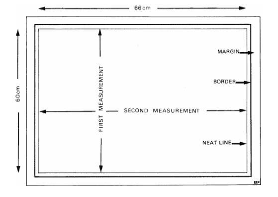
If any cartographic detail extends beyond the neat line, extend the measurement to include the cartographic detail. If there is no neat line or if the map, etc., bleeds off the edge of the sheet, measure the maximum extent of the cartographic detail.
For bound material, record height and, optionally, width in cm. For multiple volumes, record the range of heights.
Examples:
300 __ ‡a 1 atlas (3 volumes) : ‡b manuscript, color, illustrated ; ‡c 34-38 cm
300 __ ‡a 1 map : ‡b manuscript ; ‡c 50 x 61 cm
33X
Choose as appropriate from the RDA lists in sections 6.9.1.3, 3.2.1.3, and 3.3.1.3. Most commonly:
336 (content type): ‡a cartographic image ‡2 rdacontent
337 (media type): ‡a unmediated ‡2 rdamedia
338 (carrier type): ‡a sheet or ‡a volume or ‡a roll ‡2 rdacarrier
5XX
545: Biographical/Historical Data
Follow local usage. Provide information on the material’s creator or subject (cartographer, land owner, company, etc.) as relevant.
520: Summary
Comment on:
- Genre and form, and if the material is handwritten by the person intellectually responsible for the work, or is signed. “Manuscript atlas, in the hand of François Azan and in a second unidentified hand, of the ports and coasts of the Mediterranean sea […]”, “Sketch map in the author’s hand, signed, […]”, “Manuscript map, signed by the surveyor and the chief engineer […]”.
- Date of the situation depicted on the map, if not apparent from the title and if different from the time of production. “Depicts boundaries as of March-August, 1939”, or “Shows sites of 1809 battles”.
- Geographic coverage of the material. “Covers Atlantic Ocean from as far north as Halifax, N.S., and as far south as Puerto Rico”, or “Covers area bounded by Julia St., Barrone St., Bienville St., and the Mississippi River.”
- Specific geographic features, including topographic details, geological details (especially for mining-related maps), political or other boundary lines, and bathymetric/hydrographic details such as seafloor relief and depths.
- Related personal or corporate names, or topical subjects, to justify 6xx access points.
561: Ownership and Custodial History
For transferred to the Beinecke Library from the YUL Map Collection, use the standard wording, following any additional provenance information: “Transferred from the Yale University Library Map Collection.”
546: Language
Indicate location and content of text when present.
Examples:
546 __ ‡a Accompanying text in Italian.
546 __ ‡a Legend in English and Latin.
546 __ ‡a Manuscript annotations in French.
546 __ ‡a Place names in Latin.
546 __ ‡a No linguistic content.
500: General Notes
Required notes, when applicable:
- Coordinates (see 034 and 255): “Coordinates not present on map and are approximated” or “Coordinates not present on map”.
- Title (see 245): “Title devised by cataloger”, or source of title if not taken from a preferred source.
- Physical description: Note important physical details (including support, binding, watermark); and illustrations and decorative elements.
- Relief: Always make a note on the method of relief portrayal, if present on map, such as “Relief shown by contours, hachures, and spot heights, “Relief shown pictorially”, “Raised relief”, or “Depths shown by soundings”. See Glossary for relief methods.
Optional:
- If the manuscript item is the basis of a printed publication, supply the publication details.
524: Preferred Citation
Use the 1xx name, if applicable, in direct order, followed by a comma, followed by the title in 245 ‡a.
Example:
524 __ ‡a Ernest W. Branch, Lakeside Park Annex, Tewksbury. General Collection, Beinecke Rare Book and Manuscript Library, Yale University.
65X
650
Use the form subdivision ‡v Maps under topical headings for individual maps or collections of maps on those subjects. For example: ‡a Railroads ‡z [Geographic name] ‡v Maps. It’s also possible to use ‡v Maps under individual corporate bodies in 610.
For cadastral maps, relevant headings may include 650 _0 ‡a Real property ‡z [geographic area] ‡v Maps or 650 _0 ‡a Real estate development ‡z [geographic area] ‡v Maps.
651
Include one or more 651s ‡a [country, region, municipality, etc.] ‡v Maps to represent the total area of coverage of the map.
655
Include at minimum ‡a Manuscript maps. ‡2 lcgft
When possible, also include a more specific Library of Congress Genre/Form Term. Consult the Cartographic Materials 655 Form/Genre Headings list maintained by Cataloging @ Yale (https://web.library.yale.edu/cataloging/cartographic/655 [9]).
7XX
700, 710, 713: Always provide a relationship designator in subfield ‡e. Use one of the following terms:
- Cartographer (for maps with multiple creators)
- Colourist (An entity responsible for applying color to drawings, prints, photographs, maps, etc.)
- Commissioning body (An agent responsible for commissioning a work)
- Illustrator (An agent contributing to an expression of a work by supplementing the primary content with drawings, diagrams, photographs, etc.)
- Issuing body (An agent issuing a work, such as an official organ of the body)
- Transcriber (An entity responsible for preparing a handwritten or typewritten copy from original material, including from dictated or orally recorded material)
Or another appropriate term from RDA Appendix I Relationship Designators: Relationships Between a Work, Expression, Manifestation, or Item an Agents Associated with the Resource, http://access.rdatoolkit.org/. [10]
Appendices
Mixed Material Collections Containing Maps
Create a catalog record following DACS. Apply the guidelines in the Yale University Library Manuscript Cataloging Guidelines and the Beinecke MS Unit’s Cataloging Manual.
If the cartographic material is significant to the collection, add to the collection-level record:
- 006 for “manuscript map”
- 651 for the geographic area(s) covered, with subfield ‡v Maps.
- 655 ‡a Manuscript maps. ‡2 lcgft , and any other specific terms as applicable.
If creating analytic records for individual cartographic components of the collection, use the directives in this manual.
Map Collections Using DCRM(C)
Code your catalog record as dcrmc, record type f, bibliographic level c for collection. Refer to Appendix B Collection-Level Records of DCRM(C) (p. 207-222) for more guidance. In particular:
034 and 255: If all of the items in the collection have the same scale, projection, or coordinates, supply a 034 and a 255 like single items.
- Optionally, if not all the items in the collection have the same coordinates, record the coordinates that express the overall geographic coverage of the collection as a whole.
- If the items are of more than one scale, give the statement “Scales differ” in 255.
- Otherwise do not use those fields.
300: Optionally give item or volume count instead of linear footage.
300 __ ‡a 20 ‡f maps (in 3 boxes)
Record examples
Atlas:
François Azan, Plans de plusieurs ports, rades, mouillages, caps, bancs, et dangers, GEN MSS VOL 695. Single map:
Ernest W. Branch, Lakeside Park Annex, Tewksbury, GEN MSS 1535.
Tools
(Also linked in the relevant fields)
- Bounding Box, Klokan Technologies. https://boundingbox.klokantech.com/ [3]
- Cartographic Data Source Codes, Library of Congress.
https://www.loc.gov/standards/sourcelist/cartographic-data.html [11]
- Cartographic Materials 655 Form/Genre Headings, Cataloging @ Yale.
https://web.library.yale.edu/cataloging/cartographic/655 [12]
- Degrees Minutes Seconds to/from Decimal Degrees converter, Federal Communications Commission.
https://www.fcc.gov/media/radio/dms-decimal [13]
- Map Scale Calculator, MapTools.
https://maptools.com/scale_calculator [14]
- MARC Code List for Geographic Areas, Library of Congress
https://www.loc.gov/marc/geoareas/gacs_name.html [15]
- Subclass G (Cartographic Materials) - Geographic Cutter Numbers table from the Library of Congress (https://www.loc.gov/catdir/cpso/GCutter.pdf [7]) (keyword-searchable pdf document)
Reference Resources
- Cartographic Cataloging, Cataloging @ Yale.
https://web.library.yale.edu/cataloging/cartographic [16]
- DCRM(C). https://rbms.info/dcrm/dcrmc/ [1].
- Larsgarrd, Mary. Maps and Related Cartographic Materials: Cataloging, Classification, and Bibliographic Control. Routledge, revised edition 2013.
https://books.google.com/books?id=ZD19HBFhag8C [17]
- Relevant documentation from the Beinecke Library’s Rare Book Unit:
Map cataloging: http://beinecke1.library.yale.edu/info/bookcataloging/map_cataloging.htm [18]
Atlases: http://beinecke1.library.yale.edu/info/bookcataloging/atlases.htm [19]
Glossary
(For more terms, see DCRM(C) p. 337-359)
Atlas: A volume of maps, plates, engravings, tables, etc., with or without descriptive text.
Geographic coordinates: Coordinates on Earth in terms of latitude (the north–south position of a point on the Earth’s surface) and longitude (the east–west position of a point on the Earth’s surface). Expressed in decimal degrees or in degrees/minutes/seconds.
Neat line: A line, usually grid or graticule, that encloses the detail of a map.
Projection: Mathematical constructs used to represent a geographic surface that is three-dimensional on two-dimensional surface.
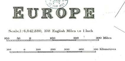
Relief: Inequalities of elevation and the configuration of land features on the surface of the Earth that may be represented on maps or charts by contours, hypsometric tints, shading, spot heights, hachures, etc. (see image below).
Scale: The ratio of distances on a map, or other cartographic item, to the actual distances they represent on earth. Scale gives an indication of a map’s level of detail. Statements of scale appear in various forms, including the representative fraction (“1:24,000”, which is the same as “1/24,000”), a verbal scale (“A hundred miles to an inch” “1 inch = 1 mile”), and a bar/graphic scale.